Santa Catalina Island

… was named in honor of Saint Catherine of Alexandria by Sebastián Vizcaíno on this date in 1602, her feast day. The indigenous Pimungan called their island Pimu.

In 310, Emperor Maximus ordered Catherine broken on the wheel for being a Christian, but she touched the wheel and it was destroyed. She was beheaded, and her body whisked away by angels.

According to The Catholic Community Forum, Saint Catherine is the patron saint of “apologists, craftsmen who work with a wheel (potters, spinners, etc.), archivists, attornies, barristers, dying people, educators, girls, jurists, knife grinders, knife sharpeners, lawyers, librarians, libraries, maidens, mechanics, millers, nurses, old maids, philosophers, potters, preachers, scholars, schoolchildren, scribes, secretaries spinners, spinsters, stenographers, students, tanners, teachers, theologians, turners, unmarried girls, wheelwrights.”

Twenty-six miles across the sea
Santa Catalina is a-waitin’ for me
Santa Catalina, the island of romance
Romance, romance, romance

Water all around it everywhere
Tropical trees and the salty air
But for me the thing that’s a-waitin’ there, romance

Visit Catalina Island’s Official Website.

Chile: 4×4 by 4,000 miles

Pultizer prize-winning critic (his topic just happens to be automobiles) Dan Neil reports on his car trip in Chile. He begins:

I’ve got a thousand miles behind me and three thousand to go. I’ve got a dashboard tan. Hammer down. Radar love.

It’s the middle of the night in the middle of the Atacama Desert, along a stretch of haunted ground called the Pampa del Indio Muerto. I don’t speak Spanish but I get the idea. This is the land that rain forgot.

Guidebooks call this part of northern Chile “lunar” or “Martian,” and during the day it’s understandable because the cracked lifelessness stretches to the ashy horizon. Water seems like folklore. But at night, well, night is different. Northern Chile has dark and transparent air — silver-lidded observatories eye the heavens from nearby mountaintops — and the sky is whitewashed with stars. You will never feel more Earthbound. Here you can appreciate your significance in the universe, and the news is not good.

Key quote: “But the fact is, most of the world isn’t paved, and that’s the part I long to see.”

I’d like to quote more, but go read Neil’s report — and don’t miss the photos.

Politicians need to know which way the wind doth blow

Winged Victory

Winged Victory, a 16-foot high weather vane, adorns the dome. With a purchase price of $160 the weather vane was less expensive than a traditional statue. She was designed after the Greek statue Nike of Samothrace with arms and head added. Her right hand holds the torch of liberty and her left hand presents a victory wreath. In the 1950s the legislature had her immobilized to face the front of the Capitol. Once restoration was completed in 1981, the Winged Victory was set free to turn in the wind once again.

Source: Arizona State Library

NewMexiKen photo 2003. Click to enlarge.

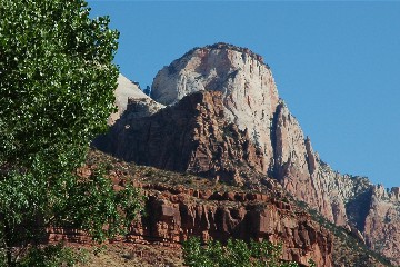
Zion National Park (Utah)

… was established on this date in 1919.

Zion

Zion is an ancient Hebrew word meaning a place of refuge or sanctuary. Protected within the park’s 229 square miles is a dramatic landscape of sculptured canyons and soaring cliffs. Zion is located at the junction of the Colorado Plateau, Great Basin and Mojave Desert provinces. This unique geography and the variety of life zones within the park make Zion significant as a place of unusual plant and animal diversity.

Zion National Park

NewMexiKen photo, 2005

Gila Cliff Dwellings National Monument (New Mexico)

… was designated a national monument on this date in 1907.

Gila Cliff Dwellings

Gila Cliff Dwellings National Monument offers a glimpse of the homes and lives of the people of the Mogollon culture who lived in the Gila Wilderness from the 1280s through the early 1300s. The surroundings probably look today very much like they did when the cliff dwellings were inhabited. It is surrounded by the Gila National Forest and lies in the middle of the Gila Wilderness, the nation’s first designated wilderness area. Wildernes designation means that the wilderness character of the area will not be altered by the intrusion of roads or other evidence of human presence.

Gila Cliff Dwellings National Monument

Oklahoma!

… was admitted to the Union as the 46th state on this date in 1907.

The official song and anthem of the State of Oklahoma is “Oklahoma,” composed and written by Richard Rodgers and Oscar Hammerstein.

Brand new state, Brand new state, gonna treat you great!
Gonna give you barley, carrots and pertaters,
Pasture fer the cattle, Spinach and Termayters!
Flowers on the prairie where the June bugs zoom,
Plen’y of air and plen’y of room,
Plen’y of room to swing a rope!
Plen’y of heart and plen’y of hope!

Oklahoma, where the wind comes sweepin’ down the plain,
And the wavin’ wheat can sure smell sweet
When the wind comes right behind the rain.
Oklahoma, ev’ry night my honey lamb and I
Sit alone and talk and watch a hawk makin’ lazy circles in the sky.

We know we belong to the land
And the land we belong to is grand!
And when we say – Yeeow! Ayipioeeay!
We’re only sayin’ You’re doin’ fine, Oklahoma! Oklahoma – O.K.

Oklahoma comes from two Choctaw words: “okla” meaning people and “humma” meaning red, so the state’s name means “red people.”

Highest point: Black Mesa (4,973 feet)
Lowest point: Little River (287 feet)
Oklahoma has 77 counties
The state ranks 20th in size (69,898 square miles)
The Oklahoma state animal is the American buffalo (Bison bison)

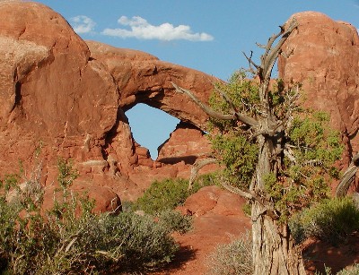
Arches National Park (Utah)

… was redesignated from national monument to national park on this date in 1971.

Arches

For there is a cloud on my horizon. A small dark cloud no bigger than my hand. Its name is Progress.

The ease and relative freedom of this lovely job at Arches follow from the comparative absence of the motorized tourists, who stay away by the millions. And they stay away because of the unpaved entrance road, the unflushable toilets in the campgrounds, and the fact that most of them have never even heard of Arches National Monument.

The Master Plan has been fulfilled. Where once a few adventurous people came on weekends to camp for a night or two and enjoy a taste of the primitive and remote, you will now find serpentine streams of baroque automobiles pouring in and out, all through the spring and summer, in numbers that would have seemed fantastic when I worked there: from 3,000 to 30,000 to 300,000 per year, the “visitation,” as they call it, mounts ever upward [769,672 visitors in 2003].

Progress has come at last to Arches, after a million years of neglect. Industrial Tourism has arrived.

— Edward Abbey, Desert Solitaire (1968)

NewMexiKen photo, 2003

San Antonio Missions National Historical Park (Texas)

… was established on this date in 1978.

San Antonio Missions

Four Spanish frontier missions, part of a colonization system that stretched across the Spanish Southwest in the 17th, 18th, 19th centuries, are preserved here. They include Missions San Jose, San Juan, Espada, and Concepcion. The park, containing many cultural sites along with some natural areas, was established in 1978. The park covers about 819 acres.

National Park Service

Jean Lafitte National Historical Park and Preserve (Louisiana)

… was authorized on this date in 1978.

Jean Lafitte NHP&P

Jean Lafitte National Historical Park and Preserve was established to preserve significant examples of the rich natural and cultural resources of Louisiana’s Mississippi Delta region. The park seeks to illustrate the influence of environment and history on the development of a unique regional culture.

The park consists of six physically separate sites and a park headquarters located in southeastern Louisiana. The sites in Lafayette, Thibodaux, and Eunice interpret the Acadian culture of the area. The Barataria Preserve (in Marrero) interprets the natural and cultural history of the uplands, swamps, and marshlands of the region. Six miles southeast of New Orleans is the Chalmette Battlefield and National Cemetery, site of the 1815 Battle of New Orleans and the final resting place for soldiers from the Civil War, Spanish-American War, World Wars I and II, and Vietnam. At 419 Decatur Street in the historic French Quarter is the park’s visitor center for New Orleans. This center interprets the history of New Orleans and the diverse cultures of Louisiana’s Mississippi Delta region. The Park Headquarters is located in New Orleans.

National Park Service

Kaloko-Honokohau National Historical Park (Hawaii)

… was established on this date in 1978.

Kaloko-Honokohau NHS

Established in 1978 for the preservation, protection and interpretation of traditional native Hawaiian activities and culture, Kaloko-Honokohau NHP is an 1160 acre park full of incredible cultural and historical significance. It is the site of an ancient Hawaiian settlement which encompasses portions of four different ahupua’a, or traditional sea to mountain land divisions. Resources include fishponds, kahua (house site platforms), ki’i pohaku (petroglyphs), holua (stone slide), and heiau (religious site).

National Park Service

Badlands National Park (South Dakota)

… was upgraded from national monument to national park on this date in 1978.

Badlands National Park

Located in southwestern South Dakota, Badlands National Park consists of 244,000 acres of sharply eroded buttes, pinnacles and spires blended with the largest, protected mixed grass prairie in the United States. The Badlands Wilderness Area covers 64,000 acres and is the site of the reintroduction of the black-footed ferret, the most endangered land mammal in North America. The Stronghold Unit is co-managed with the Oglala Sioux Tribe and includes sites of 1890s Ghost Dances. Established as Badlands National Monument in 1939, the area was redesignated “National Park” in 1978. Over 11,000 years of human history pale to the ages old paleontological resources. Badlands National Park contains the world’s richest Oligocene epoch fossil beds, dating 23 to 35 million years old. Scientists can study the evolution of mammal species such as the horse, sheep, rhinoceros and pig in the Badlands formations.

National Park Service

Now we’re getting places

The Mossberg Solution takes a look at the online mapping services:

This week, my assistant Katie Boehret and I tested the old reliable, MapQuest, against Google Local, http://maps.google.com, and a new, enhanced version of Yahoo Maps, http://maps.yahoo.com/beta. Yahoo’s new site was just released last week, and it’s still in its “beta,” or test, phase.

As everyone who has used online mapping knows, it has its limitations. The mapping services too rarely spit out the kind of smart, speedy routes a savvy local driver would choose. Their suggested routes are generally more convoluted, and sometimes wrong. But, in most cases, they do get you where you’re going, and thus are a boon to drivers unfamiliar with the area in question.

These newer sites are free, like MapQuest, but they offer some fancy features, like the ability to pan across a map simply by moving your mouse’s cursor, or zooming in or out on a location quickly. Google adds satellite photos of the actual locations, down to the trees in your front yard.

MapQuest looks a little dowdy by comparison to the newcomers, but it works for a lot of folks because it gets people from point A to point B, without any extra fuss. So, we tested these new features from Google and Yahoo to see if they were actually useful, or just a lot of hype that muddied up the direction-retrieval process.

Overall, we concluded that, for the sake of getting where you’re going with the most-thorough directions, MapQuest still does the best job, with the most accurate directions. But Yahoo has a multipoint routing feature that’s valuable. And, for some, the ability to quickly pan a geographic region on Yahoo and Google — with satellite photos on the latter — can familiarize them with the surrounding area and make the drive easier.

There’s more.

NoVa

Anyone who has lived in Northern Virginia (that is, the Washington, D.C., Virginia suburbs) as NewMexiKen did for 14+ years, will appreciate this from Joel Achenbach:

Those of you who aren’t familiar with the domain of Lord Fairfax should understand that it used to be a lovely Piedmont region with cornfields and vineyards and the occasional horsey person in jodhpurs, but now has roughly 300 million residents, all of them currently stuck in a traffic jam. Main Street is something called Route 7, also known as the Leesburg Pike, and it has become 40 miles of uninterrupted retail shopping. This sprawling region is culturally more diverse than you’d think, thanks to the immigrant population, and it’s full of swing voters. The Commonwealth of Virginia went for Nixon in 1968, and has been a red state since, but the dramatic growth in population has been in NoVa. Anyone hoping to win the White House in 2008 will want to get out there on the Pike and work the entrances to the big box stores. Hint: Walking may be faster than driving.

Tuskegee Airmen National Historic Site (Alabama)

… was authorized on this date in 1998.

The sky was the limit–literally! After the successful flight of Orville and Wilbur Wright in 1903, Americans of all races were stung by the love bug of flight. In the late 1920’s and 1930’s African Americans in great numbers began their love affair with flight. They learned the basics of flight on either American soil or abroad, and created their own flight schools and clubs.

This love affair was kindled in the late 1930’s, when the United States Government created Civilian Pilot Training Programs throughout the country to provide a surplus of pilots in case of a national emergency. African Americans were included in these programs, although trained at segregated facilities.

Their love of flight became fully ablaze amid World War II as political pressure challenged the government to expand the role of African Americans in the military. The Army Air Corps was the first agency to accept the challenge. Tuskegee Institute, a small black college in Alabama, was selected to host the “military experiment” to train African American pilots and support staff–thus the Tuskegee Airmen were born.

The outstanding performance of the over 15,000 men and women who shared the “Tuskegee Experience” from 1942-1946, is immortalized at the Tuskegee Airmen National Historic Site.

Source: National Park Service

The Spirit of Tombstone

Just in time for Halloween, a good travel article about Tombstone, Arizona, from the Los Angeles Times.

They say ghosts walk the streets of this dusty desert town. It’s easy to understand why.

With a name like Tombstone and a frenzied history of bloodshed, this outpost near the southwestern edge of the United States has a reputation that’s — well, haunted. And it doesn’t help to see a dozen gunslingers die each day in the town’s sandy red dirt.

The fights are staged, but Tombstone’s checkered past is real, I learned when I spent a few days here earlier this month searching for ghosts. Tombstone, which advertises itself as “The Town Too Tough to Die,” surprised me. So did the spirits of its past.

Nevada

Nevada was admitted to the Union as the 36th state on this date in 1864.

In Spanish “nevada” means snow-capped.

The Nevada state bird: Mountain Bluebird
State animal: Desert Bighorn Sheep
State reptile: Desert Tortoise

Nevada is the seventh largest state: 110,540 square miles. It has 17 counties.

Salinas Pueblo Missions National Monument (New Mexico)

… was authorized on this date in 1980.

Salinas Pueblo Missions

Once, thriving American Indian trade communities of Tiwa and Tompiro speaking Puebloans inhabited this remote frontier area of central New Mexico. Early in the 17th-century Spanish Franciscans found the area ripe for their missionary efforts. However, by the late 1670s the entire Salinas District, as the Spanish had named it, was depopulated of both Indian and Spaniard. What remains today are austere yet beautiful reminders of this earliest contact between Pueblo Indians and Spanish Colonials: the ruins of four mission churches, at Quarai, Abó, and Gran Quivira and the partially excavated pueblo of Las Humanas or, as it is known today, Gran Quivira. Established in 1980 through the combination of two New Mexico State Monuments and the former Gran Quivira National Monument, the present Monument comprises a total of 1,100 acres.

Source: National Park Service

Note: Other sources say 1988.

Fossil Butte National Monument (Wyoming)

… was authorized on this date in 1972.

Fossil Butte

This 50-million year old lake bed is one of the richest fossil localities in the world. Recorded in limestone are dynamic and complete paleoecosystems that spanned two million years. Preservation is so complete that it allows for detailed study of climate change and its effects on biological communities.

Visitors discover that this resource displays the interrelationships of plants, insects, fishes, reptiles and mammals, like few other known fossil sites. The relevance and challenge of study and preservation of this ancient ecosystem are equal to those of a modern ecosystem.

The surface topography of Fossil Butte is now covered by a high cold desert. Sagebrush is the dominant vegetation at the lower elevations, while limber pine and aspen occur on the slopes. Pronghorn, Mule deer and a variety of birds are commonly seen. Moose, elk and beaver are sometimes observed.

Source: National Park Service

Big bad wolf

From an article on the wolves in Yellowstone Park in today’s New York Times:

Nearly absent for decades, willows have roared back to life in Yellowstone, and the reason, Mr. Smith believes, is that 10 years after wolves were introduced to Yellowstone, the park is full of them, dispersed across 13 packs.

He says the wolves have changed the park’s ecology in many ways; for one, they have scared the elk to high ground and away from browsing on every willow shoot by rivers and streams.

“Wolves have caused a trophic cascade,” he said.

“Wolves are at the top of it all here. They change the conditions for everyone else, including willows.”

Andersonville National Historic Site

… was authorized on this date in 1970. It is located in Georgia.

Andersonville NHS

Andersonville, or Camp Sumter as it was officially known, was one of the largest of many Confederate military prisons established during the Civil War. It was built early in 1864 after Confederate officials decided to move the large number of Federal prisoners kept in and around Richmond, Virginia, to a place of greater security and a more abundant food supply. During the 14 months the prison existed, more than 45,000 Union soldiers were confined here. Of these, almost 13,000 died from disease, poor sanitation, malnutrition, overcrowding, or exposure to the elements.

Today, Andersonville National Historic Site is the only park in the National Park System to serve as a memorial to all American prisoners of war throughout the nation’s history.

Source: National Park Service

Wolf Trap National Park for the Performing Arts

… was authorized on this date in 1966.

Wolf Trap Farm Park

Wolf Trap National Park for the Performing Arts began as a gift to the American people from Catherine Filene Shouse. Encroaching roads and suburbs inspired Mrs. Shouse to preserve this former farm as a park. In 1966 Congress accepted Mrs. Shouse’s gift and authorized Wolf Trap Farm Park (its original name) as the first national park for the performing arts. Through a fruitful partnership between the National Park Service and the Wolf Trap Foundation, Wolf Trap National Park for the Performing Arts offers a wealth of natural and cultural resources to the community and to the nation.

National Park Service

NewMexiKen and family once upon a time lived in one of the encroaching suburbs just down the street from Wolf Trap Farm Park.

Saguaro National Monument

… became Saguaro National Park on this date in 1994.

Saguaro National Park

This unique desert is home to the most recognizable cactus in the world, the majestic saguaro. Visitors of all ages are fascinated and enchanted by these desert giants, especially their many interesting and complex interrelationships with other desert life. Saguaro cacti provide their sweet fruits to hungry desert animals. They also provide homes to a variety of birds, such as the Harris’ hawk, Gila woodpecker and the tiny elf owl. Yet, the saguaro requires other desert plants for its very survival. During the first few years of a very long life, a young saguaro needs the shade and protection of a nurse plant such as the palo verde tree. With an average life span of 150 years, a mature saguaro may grow to a height of 50 feet and weigh over 10 tons.

Source: National Park Service